
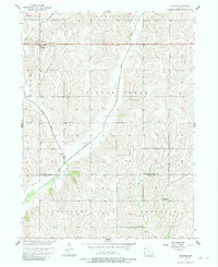
1956 Map of Treynor
USGS Topo · Published 1958About this map
Treynor stands as the primary settlement on this mid-century survey of southwest Iowa, situated where the high ground transitions into the drainage basins of the Missouri River system. The landscape is defined by the winding paths of Middle Silver Creek and Silver Creek, which cut through the townships of Hardin, Washington, and Silver Creek. This 1950s mapping project, conducted as part of the Missouri River Basin development program, captures the rural infrastructure of Pottawattamie and Mills counties just as aerial photogrammetry was becoming the standard for topographic precision. Notable landmarks for local historians include the Boxelder Sch near the southern boundary and several rural crossings, including a Footbridge over the creek branches. The map provides a clear record of the section-line road network and bridge locations like BR 1092 that served the agricultural community during this period.
Find a feature on this map
14 named features on this map. Tap any name to fly to it.
Don’t see what you’re looking for? This feature index may not catch every label — zoom into the map to look around manually.
Map Details
Editions of this 1956 Treynor Map
2 editions found
Other maps of this area

1954 · Omaha
USGS Topo · 1:250,000

1956 · Glenwood
USGS Topo · 1:24,000

1956 · Mineola
USGS Topo · 1:24,000

1956 · Mc Clelland
USGS Topo · 1:24,000

1956 · Malvern
USGS Topo · 1:24,000

1957 · Omaha
USGS Topo · 1:250,000

1957 · Taylor
USGS Topo · 1:24,000

1958 · Omaha
USGS Topo · 1:250,000

1963 · Oakland
USGS Topo · 1:24,000

1978 · Carson
USGS Topo · 1:24,000