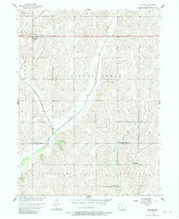
1956 Map of Treynor
USGS Topo · Published 1983About this map
Treynor stands as the primary settlement on this Western Iowa landscape, situated atop the loess hills of the Missouri River Basin. The topography is defined by the winding paths of Middle Silver Creek and Silver Creek, which cut deep drainage patterns across the townships of Hardin and Washington. To the south, the terrain descends toward the Pottawattamie and Mills County line, where the rural character is punctuated by several footbridges crossing the waterways.
Find a feature on this map
13 named features on this map. Tap any name to fly to it.
Don’t see what you’re looking for? This feature index may not catch every label — zoom into the map to look around manually.
Map Details
Editions of this 1956 Treynor Map
2 editions found
Other maps of this area

1954 · Omaha
USGS Topo · 1:250,000

1956 · Glenwood
USGS Topo · 1:24,000

1956 · Mineola
USGS Topo · 1:24,000

1956 · Treynor
USGS Topo · 1:24,000

1956 · Mc Clelland
USGS Topo · 1:24,000

1956 · Malvern
USGS Topo · 1:24,000

1957 · Omaha
USGS Topo · 1:250,000

1957 · Taylor
USGS Topo · 1:24,000

1958 · Omaha
USGS Topo · 1:250,000

1963 · Oakland
USGS Topo · 1:24,000