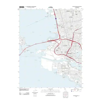
2012 Map of Oakland West
USGS Topo · Published 2012About this map
Oakland and Berkeley waterfronts are revealed in meticulous detail, illustrating the dense industrial and institutional fabric of the East Bay. The map documents the extensive port facilities of the Oakland Outer Harbor and Oakland Inner Harbor, including the Oakland Mole and various maritime terminals like the Sea-Land Terminal. The transition from industrial piers to residential enclaves is clear, with neighborhoods such as Chinatown, Adams Point, and Pill Hill appearing alongside educational centers like the University of California at Berkeley. The structural layout of the San Francisco-Oakland Bay Bridge serves as a central artery, connecting the mainland to Yerba Buena Island and Treasure Island. Significant landmarks like Jack London Square and the Yerba Buena Lighthouse provide points of interest for researchers studying the coastal evolution and urban development of this maritime hub.
Find a feature on this map
84 named features on this map. Tap any name to fly to it.
Don’t see what you’re looking for? This feature index may not catch every label — zoom into the map to look around manually.
Map Details
Editions of this 2012 Oakland West Map
This is the sole edition of this map. No revisions or reprints were ever made.
Other maps of this area

1892 · San Mateo
USGS Topo · 1:62,500

1895 · San Francisco
USGS Topo · 1:62,500

1896 · San Mateo
USGS Topo · 1:62,500

1897 · Concord
USGS Topo · 1:62,500

1899 · San Francisco
USGS Topo · 1:62,500

1899 · Haywards
USGS Topo · 1:62,500

1899 · San Mateo
USGS Topo · 1:62,500

1915 · San Mateo
USGS Topo · 1:62,500

1915 · Haywards
USGS Topo · 1:62,500

1915 · Concord
USGS Topo · 1:62,500