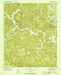
1951 Map of Oakman
USGS Topo · Published 1951About this map
Oakman and the winding Southern railroad line anchor this 1951 topographic study of the Walker and Fayette County border. The landscape is defined by the sharp relief of Propst Mountain and Clemments Mountain, where industrial and community life centers on the coal and rail corridors. Small settlements like Corona, Patton, and Coal Valley are clustered along these transit routes, each accompanied by its own local landmarks such as Mt Olive Ch and Patton Hill Fire Tower.
Find a feature on this map
68 named features on this map. Tap any name to fly to it.
Don’t see what you’re looking for? This feature index may not catch every label — zoom into the map to look around manually.
Map Details
Editions of this 1951 Oakman Map
2 editions found

Other maps of this area

1893 · Jasper
USGS Topo · 1:125,000

1949 · Parrish
USGS Topo · 1:24,000

1949 · Townley
USGS Topo · 1:24,000

1949 · Jasper
USGS Topo · 1:24,000

1949 · Oakman
USGS Topo · 1:24,000

1949 · Tutwiler School
USGS Topo · 1:24,000

1949 · Wiley
USGS Topo · 1:24,000

1951 · Jasper
USGS Topo · 1:24,000
1951 · Parrish
USGS Topo · 1:24,000
1951 · Tutwiler School
USGS Topo · 1:24,000