
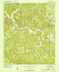
1951 Map of Oakman
USGS Topo · Published 1951About this map
Oakman serves as the primary population center in this 1951 study of the Walker and Fayette county line, situated along the Southern railroad line that dictated the region's early growth. The settlement pattern reflects an economy built on natural resources, with names like Coal Valley and Coalbed Creek hinting at the mining history that shaped the local landscape. Rural life is anchored by a network of community landmarks, including Mt Zion Ch near Patton Hill and the Old Lebanon Ch further south.
Find a feature on this map
69 named features on this map. Tap any name to fly to it.
Don’t see what you’re looking for? This feature index may not catch every label — zoom into the map to look around manually.
Map Details
Editions of this 1951 Oakman Map
2 editions found
Other maps of this area

1893 · Jasper
USGS Topo · 1:125,000

1949 · Parrish
USGS Topo · 1:24,000

1949 · Townley
USGS Topo · 1:24,000

1949 · Jasper
USGS Topo · 1:24,000

1949 · Oakman
USGS Topo · 1:24,000

1949 · Tutwiler School
USGS Topo · 1:24,000

1949 · Wiley
USGS Topo · 1:24,000

1951 · Jasper
USGS Topo · 1:24,000
1951 · Parrish
USGS Topo · 1:24,000
1951 · Tutwiler School
USGS Topo · 1:24,000