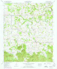
1960 Map of Oakville
USGS Topo · Published 1977About this map
The William B Bankhead National Forest defines the southern boundary of this Lawrence County landscape, where the northern foothills of Sand Mountain meet the drainage of the West Branch Flint Creek. This 1960 survey, updated in the mid-1970s, reveals a rural economy centered on small crossroads settlements like Speake and Oakville. The map is particularly rich in genealogical data, documenting numerous family burial grounds such as Dement Cem, Pruitt Cem, and Hodges Cem, many of which are located near country houses of worship like Lebanon Ch. A significant cultural landmark is identified near the center of the sheet: an Indian mound and the adjacent Camp Indian Mound, marking an ancient presence near the headwaters of Buck Branch. Agricultural features including a race track and drag strip reflect local mid-century recreational life amidst the timber and farm tracts.
Find a feature on this map
83 named features on this map. Tap any name to fly to it.
Don’t see what you’re looking for? This feature index may not catch every label — zoom into the map to look around manually.
Map Details
Editions of this 1960 Oakville Map
3 editions found
Other maps of this area

1935 · Moulton
USGS Topo · 1:24,000

1935 · Upshaw
USGS Topo · 1:24,000

1935 · Danville
USGS Topo · 1:48,000

1935 · Oakville
USGS Topo · 1:24,000

1936 · Caddo
USGS Topo · 1:24,000

1936 · Mc Kendry
USGS Topo · 1:24,000

1936 · Trinity
USGS Topo · 1:24,000

1936 · Moulton
USGS Topo · 1:48,000

1936 · Masterson
USGS Topo · 1:24,000

1936 · Stroups Crossroads
USGS Topo · 1:24,000