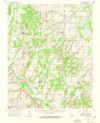
1964 Map of Oakwood
USGS Topo · Published 1980About this map
The North Canadian River carves a deep valley through the high plains of western Oklahoma, defining the character of this mid-century landscape. Small agricultural settlements like Oakwood and Eagle City serve as anchors for the surrounding rural sections, which are densely dotted with family and community landmarks. The concentration of religious and memorial sites, such as the Church of the First Born, Rising Sun Ch, and the Mt Hope Cem, reveals the deeply rooted social fabric of Dewey and Blaine counties.
Find a feature on this map
41 named features on this map. Tap any name to fly to it.
Don’t see what you’re looking for? This feature index may not catch every label — zoom into the map to look around manually.
Map Details
Editions of this 1964 Oakwood Map
2 editions found
Other maps of this area

1942 · Geary
USGS Topo · 1:62,500

1955 · Clinton
USGS Topo · 1:250,000

1955 · Woodward
USGS Topo · 1:250,000

1957 · Clinton
USGS Topo · 1:250,000

1957 · Clinton
USGS Topo · 1:62,500

1958 · Woodward
USGS Topo · 1:250,000

1962 · Putnam
USGS Topo · 1:62,500

1964 · Oakwood
USGS Topo · 1:62,500

1964 · Weatherford
USGS Topo · 1:62,500

1972 · Watonga
USGS Topo · 1:24,000