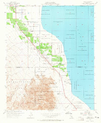
1956 Map of Oasis
USGS Topo · Published 1965About this map
The Torres Martinez Indian Reservation occupies much of this landscape in the mid-1950s, where the irrigated agricultural patterns of Oasis meet the arid margins of the Salton Sea. At an elevation of 235 feet below sea level, the map reveals a complex water management system essential for desert life, documented through numerous Wells, Artesian Wells, and a Gaging Station. Civic and utility infrastructure is concentrated near the community of Oasis, including the Oasis Sch, a State Fire Control Sta, and a State Highway Maintenance Sta. To the south and west, the terrain rises sharply into the Santa Rosa Mountains and the protected lands of Anza-Borrego State Park. Notable natural and historical markers like Travertine Rock and Fish Springs sit along the shoreline, highlighting the geological and cultural significance of this Coachella Valley basin.
Find a feature on this map
37 named features on this map. Tap any name to fly to it.
Don’t see what you’re looking for? This feature index may not catch every label — zoom into the map to look around manually.
Map Details
Editions of this 1956 Oasis Map
3 editions found
Other maps of this area

1904 · Indio
USGS Topo · 1:125,000

1931 · Vallecito
USGS Topo · 1:125,000

1940 · Cottonwood Spring
USGS Topo · 1:62,500

1940 · Durmid
USGS Topo · 1:62,500

1941 · Coachella
USGS Topo · 1:62,500

1942 · Agua Dulce
USGS Topo · 1:62,500

1943 · Vallecito
USGS Topo · 1:125,000

1943 · Coachella
USGS Topo · 1:62,500

1944 · Agua Dulce
USGS Topo · 1:62,500

1944 · Cottonwood Spring
USGS Topo · 1:62,500