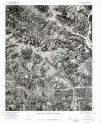
1976 Map of Oat Mountain
USGS Topo · Published 1980About this map
Oat Mountain dominates the central landscape of this 1976 orthophotoquad, serving as a stark vertical boundary between the expanding suburban developments of the San Fernando and Santa Clarita valleys. This aerial perspective, captured just after the mid-1970s, reveals the precise edge of urbanization in Granada Hills to the south and the emerging layout of Newhall in the north. The high-altitude photography provides an exceptionally clear view of the complex ridgelines and drainage patterns of the Santa Susana Mountains before further late-century development. Unlike traditional topographic maps, this rectified imagery shows the actual vegetation density and the winding paths of canyon roads, offering researchers a raw visual record of Southern California's rugged wildland-urban interface during a period of significant regional growth.
Find a feature on this map
3 named features on this map. Tap any name to fly to it.
Don’t see what you’re looking for? This feature index may not catch every label — zoom into the map to look around manually.
Map Details
Editions of this 1976 Oat Mountain Map
This is the sole edition of this map. No revisions or reprints were ever made.
Other maps of this area

1894 · Los Angeles
USGS Topo · 1:62,500

1896 · Santa Monica
USGS Topo · 1:62,500

1898 · Santa Monica
USGS Topo · 1:62,500

1900 · Los Angeles
USGS Topo · 1:62,500

1900 · Fernando
USGS Topo · 1:62,500

1901 · Southern California Sheet No. 1
USGS Topo · 1:250,000

1902 · Santa Monica
USGS Topo · 1:62,500

1903 · Calabasas
USGS Topo · 1:62,500

1903 · Camulos
USGS Topo · 1:125,000

1903 · Santa Susana
USGS Topo · 1:62,500
Featured Places
- Los Angeles, CA
- Santa Clarita, CA
- Fern Ann Falls, Unincorporated Chatsworth
- Waltz, Santa Clarita
- Deer Lake Highlands, Unincorporated Chatsworth