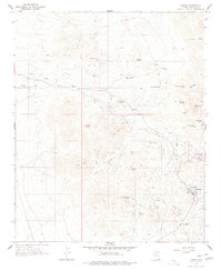
1967 Map of Oatman
USGS Topo · Published 1977About this map
The gold mining landscape of the Black Mountains comes into focus in this late 1960s study of Oatman, Arizona. This settlement serves as the central hub for a dense network of extraction sites and historic town foundations. To the northeast, the Goldroad (Site) and the associated Goldroad Mine mark a significant legacy of desert industry, while the south reveals the Old Trails (Site) near the White Chief Mine. The map documents a landscape defined by its resources, from the United Eastern Mine and Tom Reed Mine bordering the main townsite to the remote Moss Mine and Mossback Mine to the northwest. This terrain is crisscrossed by a Jeep Trail network and industrial infrastructure including a Pipeline and prominent Tailings piles, illustrating how the search for mineral wealth shaped the geography around Hardy Mtn and Silver Creek.
Find a feature on this map
36 named features on this map. Tap any name to fly to it.
Don’t see what you’re looking for? This feature index may not catch every label — zoom into the map to look around manually.
Map Details
Editions of this 1967 Oatman Map
4 editions found
Other maps of this area

1886 · Camp Mohave
USGS Topo · 1:250,000

1892 · Camp Mohave
USGS Topo · 1:250,000

1903 · Needles
USGS Topo · 1:125,000

1904 · Needles Special
USGS Topo · 1:125,000

1926 · Mohave City
USGS Topo · 1:96,000

1942 · Camp Mohave
USGS Topo · 1:250,000

1947 · Kingman
USGS Topo · 1:250,000

1948 · Kingman
USGS Topo · 1:250,000

1950 · Davis Dam
USGS Topo · 1:62,500

1950 · Needles
USGS Topo · 1:62,500