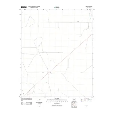
2010 Map of Obar
USGS Topo · Published 2010About this map
Obar serves as the central point of this high plains landscape in Quay County, where a grid of rural routes like Quay Road K and Lockney Rd connects small family settlements. The map illustrates a sparse but organized ranching or farming layout, with named points such as Nelson, Hughs, and Bullock situated along these straight-line roads. Geographically, the terrain is defined by seasonal watercourses, including the West Fork Nara Visa Arroyo in the northeast and Sager Draw in the southwest. For those researching local history or genealogy, the Obar Cemetery located south of the main settlement provides a vital point of reference for the families who have inhabited this part of eastern New Mexico. The infrastructure is dominated by long-distance road corridors like Obar Rd, which intersect the landscape with geometric precision.
Find a feature on this map
13 named features on this map. Tap any name to fly to it.
Don’t see what you’re looking for? This feature index may not catch every label — zoom into the map to look around manually.
Map Details
Editions of this 2010 Obar Map
This is the sole edition of this map. No revisions or reprints were ever made.
Other maps of this area
1954 · Tucumcari
USGS Topo · 1:250,000
1958 · Tucumcari
USGS Topo · 1:250,000
1962 · Logan
USGS Topo · 1:62,500
1966 · Cherokee Valley
USGS Topo · 1:24,000
1966 · Lockney
USGS Topo · 1:24,000
1968 · Cammak Camp
USGS Topo · 1:24,000
1968 · Sanchez Springs
USGS Topo · 1:24,000
1971 · Kerlin Hill
USGS Topo · 1:24,000
1971 · Doyle Hill
USGS Topo · 1:24,000
1971 · Obar
USGS Topo · 1:24,000