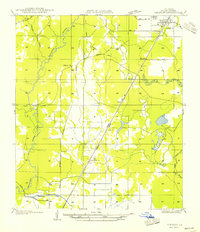
1954 Map of Oberlin
USGS Topo · Published 1954About this map
The Oberlin townsite serves as the hub of this mid-century survey, situated near the intersection of St Hy 25 and St Hy No .52. The landscape is defined by the winding course of the Calcasieu River to the west and the industrial imprint of the Missouri Pacific Railroad cutting diagonally through the parish. Smaller rural communities like Benard, Moeling, and Houston dot the rail line, while an extensive network of Old Logging Railroad Grades hints at the region's timber history.
Find a feature on this map
22 named features on this map. Tap any name to fly to it.
Don’t see what you’re looking for? This feature index may not catch every label — zoom into the map to look around manually.
Map Details
Editions of this 1954 Oberlin Map
This is the sole edition of this map. No revisions or reprints were ever made.
Other maps of this area

1935 · Mittie
USGS Topo · 1:31,680

1947 · Kinder
USGS Topo · 1:31,680

1947 · Foley
USGS Topo · 1:31,680

1947 · Oberlin
USGS Topo · 1:31,680

1947 · Pine Chapel
USGS Topo · 1:31,680

1947 · Le Blanc
USGS Topo · 1:31,680

1947 · Elton
USGS Topo · 1:31,680

1947 · Edna
USGS Topo · 1:31,680
1948 · Mittie
USGS Topo · 1:24,000
1948 · Pine Chapel
USGS Topo · 1:24,000