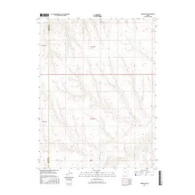
2015 Map of Oberlin SW
USGS Topo · Published 2015About this map
Saint Johns Cem sits on the high plains at the northern edge of this high-plains landscape, overlooking the complex drainage network that feeds the Sappa Creek system. The terrain is defined by the sharp incisions of seasonal watercourses like Lambs Draw and Johnson Draw, which carve through the plateau toward the larger basins of the S Fork Sappa Cr and N Fork Sappa Cr. This 2015 survey illustrates a rural landscape structured by the Public Land Survey System, where a grid of section-line roads, including 500th Rd and 100th Rd, provides the primary framework for movement across the county line between Rawlins Co and Decatur Co. The sparse distribution of named features highlights the region's character as a dedicated agricultural and ranching interior, where water management and cemetery locations serve as the primary landmarks of human presence.
Find a feature on this map
21 named features on this map. Tap any name to fly to it.
Don’t see what you’re looking for? This feature index may not catch every label — zoom into the map to look around manually.
Map Details
Editions of this 2015 Oberlin SW Map
This is the sole edition of this map. No revisions or reprints were ever made.
Other maps of this area
1951 · Selden
USGS Topo · 1:62,500
1951 · Herndon
USGS Topo · 1:62,500
1951 · Achilles
USGS Topo · 1:62,500
1951 · Oberlin
USGS Topo · 1:62,500

1954 · Goodland
USGS Topo · 1:250,000

1956 · Goodland
USGS Topo · 1:250,000

1957 · Goodland
USGS Topo · 1:250,000
1965 · Oberlin
USGS Topo · 1:24,000
1965 · Oberlin SW
USGS Topo · 1:24,000
1965 · Achilles
USGS Topo · 1:24,000