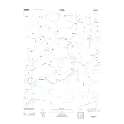
2013 Map of Obey City
USGS Topo · Published 2013About this map
Obey City sits at the heart of this landscape where the E Fork Obey River and W Fork Obey River carve through the plateau. This 2013 survey illustrates a region defined by scattered mountain communities and ridges named for early settlers, such as Flower Mountain and Gunter Mountain. The settlement pattern follows the high ground between hollows, with nodes of activity at Hanging Limb and Cliff Springs. Notable for local historians is the documentation of family-named landmarks like Phillips Ford and the Doubling Spur mine area. The topography is intricately detailed, showing how Meadow Cr and Garrison Br drain the southern reaches near Mineral Springs, while the northern terrain rises toward France Mountain and Brushy Mountain. These named gaps and ridges provide a clear view of how geography dictated the placement of rural lanes and small-scale land use in the Cumberland Plateau region.
Find a feature on this map
145 named features on this map. Tap any name to fly to it.
Don’t see what you’re looking for? This feature index may not catch every label — zoom into the map to look around manually.
Map Details
Editions of this 2013 Obey City Map
This is the sole edition of this map. No revisions or reprints were ever made.
Other maps of this area

1897 · Standingstone
USGS Topo · 1:125,000

1898 · Standingstone
USGS Topo · 1:125,000

1935 · Isoline
USGS Topo · 1:24,000

1935 · Campbell Junction
USGS Topo · 1:24,000

1935 · Clarkrange
USGS Topo · 1:24,000

1943 · Cookeville
USGS Topo · 1:100,000

1944 · Cookeville
USGS Topo · 1:100,000

1946 · Campbell Junction
USGS Topo · 1:24,000
1946 · Isoline
USGS Topo · 1:24,000

1946 · Clarkrange
USGS Topo · 1:24,000