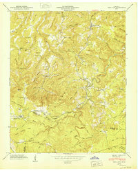
1950 Map of Obey City
USGS Topo · Published 1950About this map
The Cumberland Plateau defines this mid-century landscape in Overton County, characterized by a complex network of ridges and hollows that historically dictated settlement patterns. The Tennessee Central railroad cuts through the center of the sheet, connecting industrial outposts like Obey City and Cliff Springs. This transportation corridor was vital for the region's extraction and timber economies, as evidenced by the numerous hollows named for specific local camps and resources, such as Sunk Mill Hollow and Peachstone Camp Hollow.
Find a feature on this map
105 named features on this map. Tap any name to fly to it.
Don’t see what you’re looking for? This feature index may not catch every label — zoom into the map to look around manually.
Map Details
Editions of this 1950 Obey City Map
This is the sole edition of this map. No revisions or reprints were ever made.
Other maps of this area

1897 · Standingstone
USGS Topo · 1:125,000

1898 · Standingstone
USGS Topo · 1:125,000

1935 · Isoline
USGS Topo · 1:24,000

1935 · Campbell Junction
USGS Topo · 1:24,000

1935 · Clarkrange
USGS Topo · 1:24,000

1943 · Cookeville
USGS Topo · 1:100,000

1944 · Cookeville
USGS Topo · 1:100,000

1946 · Campbell Junction
USGS Topo · 1:24,000
1946 · Isoline
USGS Topo · 1:24,000

1946 · Clarkrange
USGS Topo · 1:24,000