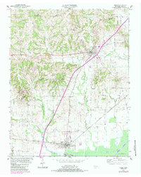
1950 Map of Obion
USGS Topo · Published 1983About this map
Obion and Troy anchor this West Tennessee landscape, surveyed in 1950 and updated with 1980s data. The geography is defined by the winding course of the Obion River to the south and the drainage basins of Richland Creek and Troy Creek to the north. A dense network of rural landmarks provides significant genealogical value, including family-named sites like Hogue Cem, Beard Cem, and Simpson Cem. Small communities and religious centers such as Englewood and Mt Moriah Ch are connected by the prominent corridor of Highway 51. The presence of the Gooch Wildlife Management Area near the river bottomlands highlights the preservation of wetlands in a region otherwise dominated by agricultural upland ridges like Terrace Hill.
Find a feature on this map
26 named features on this map. Tap any name to fly to it.
Don’t see what you’re looking for? This feature index may not catch every label — zoom into the map to look around manually.
Map Details
Editions of this 1950 Obion Map
2 editions found
Other maps of this area

1925 · Reelfoot Lake
USGS Topo · 1:62,500

1939 · Reelfoot Lake
USGS Topo · 1:62,500

1939 · Dyersburg
USGS Topo · 1:62,500

1950 · Obion
USGS Topo · 1:24,000

1950 · Rives
USGS Topo · 1:24,000

1951 · Obion
USGS Topo · 1:24,000

1951 · Rives
USGS Topo · 1:24,000

1952 · Lane
USGS Topo · 1:24,000

1954 · Union City
USGS Topo · 1:24,000

1956 · Reelfoot Lake
USGS Topo · 1:62,500