
1950 Map of Obion
USGS Topo · Published 1950About this map
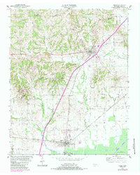
Obion and Troy anchor this mid-century topographic record of Northwest Tennessee, showing a landscape defined by its waterways and rail connections. The Illinois Central railroad bisects the terrain, running north-south through the village of Obion, while the engineered channel of the Obion River Canal cuts across the southern wetlands. The rural character of the county is evidenced by a high density of country churches and burial grounds, including Bethlehem Cem, Camp Ground Cem, and Mt Moriah Ch, which often served as the social centers for outlying farming families.
Find a feature on this map
29 named features on this map. Tap any name to fly to it.
Don’t see what you’re looking for? This feature index may not catch every label — zoom into the map to look around manually.
Map Details
Editions of this 1950 Obion Map
2 editions found
Other maps of this area

1925 · Reelfoot Lake
USGS Topo · 1:62,500

1939 · Reelfoot Lake
USGS Topo · 1:62,500

1939 · Dyersburg
USGS Topo · 1:62,500

1950 · Rives
USGS Topo · 1:24,000

1951 · Obion
USGS Topo · 1:24,000

1951 · Rives
USGS Topo · 1:24,000

1952 · Lane
USGS Topo · 1:24,000

1954 · Union City
USGS Topo · 1:24,000

1956 · Reelfoot Lake
USGS Topo · 1:62,500

1956 · Dyersburg
USGS Topo · 1:250,000