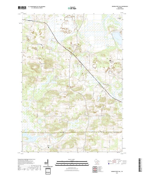
2022 Map of Observatory Hill
USGS Topo · Published 2022About this map
Observatory Hill rises above a landscape defined by the winding courses of the Grand River and the Fox River at the boundary of Marquette and Columbia counties. The area is characterized by significant wetland systems and small water bodies such as Mulhern Lake and the Madden Lakes. The settlement of Glen Oak sits in the northwest, while the southern portion of the map is marked by the Dates Millpond on French Creek. This region maintains a strong connection to its pioneer roots, visible in the distribution of community landmarks like the Greenwood Presbyterian Cemetery and the North Marcellon Cemetery. The network of country roads, including County Highway O and County Road B, connects these rural outposts across a terrain of glacial drumlins and river bottomlands.
Find a feature on this map
50 named features on this map. Tap any name to fly to it.
Don’t see what you’re looking for? This feature index may not catch every label — zoom into the map to look around manually.
Map Details
Editions of this 2022 Observatory Hill Map
This is the sole edition of this map. No revisions or reprints were ever made.
Other maps of this area

1902 · Portage
USGS Topo · 1:62,500

1915 · Neshkoro
USGS Topo · 1:48,000

1918 · Neshkoro
USGS Topo · 1:62,500

1955 · Randolph
USGS Topo · 1:62,500

1957 · Madison
USGS Topo · 1:250,000

1960 · Madison
USGS Topo · 1:250,000

1961 · Montello
USGS Topo · 1:62,500

1962 · Portage
USGS Topo · 1:62,500

1963 · Neshkoro
USGS Topo · 1:62,500
1980 · Marquette
USGS Topo · 1:24,000