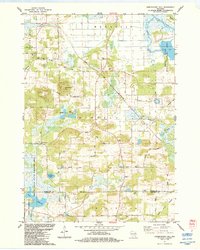
1984 Map of Observatory Hill
USGS Topo · Published 1984About this map
Observatory Hill dominates the landscape of this mid-1980s survey, marking a prominent topographic point in the glacially-carved terrain of Marquette and Columbia counties. The map preserves a rural crossroads culture, anchored by local institutions like Buffalo Ch, Greenwood Ch, and the charmingly named Wee White Kirk Ch. Historically significant lines cut across the rural grid, most notably the Indian Treaty Boundary and the Old Indian Road, which reflect the early legal and physical divisions of this region.
Find a feature on this map
49 named features on this map. Tap any name to fly to it.
Don’t see what you’re looking for? This feature index may not catch every label — zoom into the map to look around manually.
Map Details
Editions of this 1984 Observatory Hill Map
This is the sole edition of this map. No revisions or reprints were ever made.
Other maps of this area

1902 · Portage
USGS Topo · 1:62,500

1915 · Neshkoro
USGS Topo · 1:48,000

1918 · Neshkoro
USGS Topo · 1:62,500

1955 · Randolph
USGS Topo · 1:62,500

1957 · Madison
USGS Topo · 1:250,000

1960 · Madison
USGS Topo · 1:250,000

1961 · Montello
USGS Topo · 1:62,500

1962 · Portage
USGS Topo · 1:62,500

1963 · Neshkoro
USGS Topo · 1:62,500
1980 · Marquette
USGS Topo · 1:24,000