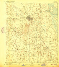
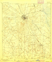
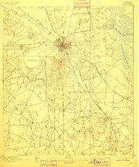
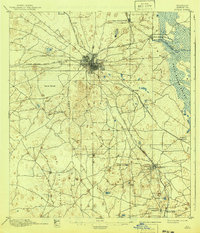
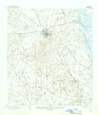
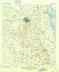
1895 Map of Ocala
USGS Topo · Published 1916About this map
Ocala serves as the central hub of this late 19th-century landscape, radiating a complex network of iron rails including the Florida Southern R. R. and the Silver Springs Ocala and Gulf R. R.. The geography is defined by a dense pocket of small settlements like Santos, Belleview, and Leitner situated amidst a varied terrain of dense scrub and sinkhole features like Taylor Spring. To the east, the waters of Silver Springs feed into the Silver Springs Run, bordering the edge of the Dead River Swamp. The map illustrates the transition from the structured urban grid of Ocala to the untamed wilderness of the Big Scrub in the south, capturing Marion County before the extensive drainage and development of the 20th century transformed the region's unique hydrology.
Find a feature on this map
28 named features on this map. Tap any name to fly to it.
Don’t see what you’re looking for? This feature index may not catch every label — zoom into the map to look around manually.
Map Details
Editions of this 1895 Ocala Map
7 editions found
Other maps of this area

1892 · Dunnellon
USGS Topo · 1:62,500

1893 · Panasoffkee
USGS Topo · 1:62,500

1893 · Citra
USGS Topo · 1:62,500

1894 · Dunnellon
USGS Topo · 1:62,500

1895 · Williston
USGS Topo · 1:62,500

1895 · Tsala Apopka
USGS Topo · 1:62,500

1895 · Citra
USGS Topo · 1:62,500

1895 · Panasoffkee
USGS Topo · 1:62,500

1895 · Ocala
USGS Topo · 1:62,500
1954 · Tsala Apopka NE
USGS Topo · 1:24,000