
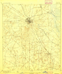
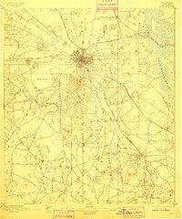
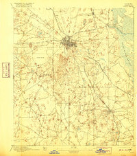
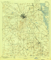
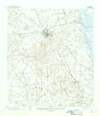
1895 Map of Ocala
USGS Topo · Published 1895About this map
The railroad hub of Ocala serves as the focal point of this late nineteenth-century Central Florida landscape, where three major rail lines converge amidst a complex terrain of sinkholes and springs. The Florida Southern R. R. and Florida Central and Peninsular R. R. create a transit corridor through the heart of Marion County, connecting small agricultural and phosphate-adjacent settlements like Santos and Kendrick. East of the city, the hydrologic importance of the region is evident at the headwaters of Silver Springs Run, which flows toward the expansive Dead River Swamp. The map details a transition from the developing town grid of Ocala to the surrounding wilderness, specifically the Big Scrub to the south. Local landmarks such as Taylor Spring and Beckett Pond are interspersed with smaller rail-stops including Agnew and Montague, providing a precise look at the county before the Great Freeze and subsequent shift in Florida's citrus and tourist economies.
Find a feature on this map
28 named features on this map. Tap any name to fly to it.
Don’t see what you’re looking for? This feature index may not catch every label — zoom into the map to look around manually.
Map Details
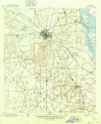
Editions of this 1895 Ocala Map
7 editions found
Other maps of this area

1892 · Dunnellon
USGS Topo · 1:62,500

1893 · Panasoffkee
USGS Topo · 1:62,500

1893 · Citra
USGS Topo · 1:62,500

1894 · Dunnellon
USGS Topo · 1:62,500

1895 · Williston
USGS Topo · 1:62,500

1895 · Tsala Apopka
USGS Topo · 1:62,500

1895 · Citra
USGS Topo · 1:62,500

1895 · Panasoffkee
USGS Topo · 1:62,500
1954 · Tsala Apopka NE
USGS Topo · 1:24,000
1954 · Cotton Plant
USGS Topo · 1:24,000