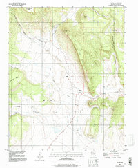
1994 Map of Ocate
USGS Topo · Published 1998About this map
Ocate and its surrounding high-altitude landscapes are defined by a complex network of mesa tops and deeply cut canyons. The settlement pattern follows the drainage of Ocate Creek, where the Ocate Mission and Guadalupe Ch served as central community landmarks for the rural population. To the west, the prominent rise of Gallinas Mesa separates the main valley from the more isolated reaches of Los Lefebres and the high flats of Laguna Salada Mesa.
Find a feature on this map
36 named features on this map. Tap any name to fly to it.
Don’t see what you’re looking for? This feature index may not catch every label — zoom into the map to look around manually.
Map Details
Editions of this 1994 Ocate Map
This is the sole edition of this map. No revisions or reprints were ever made.
Other maps of this area

1954 · Raton
USGS Topo · 1:250,000

1956 · Tooth Of Time
USGS Topo · 1:62,500

1956 · Miami
USGS Topo · 1:62,500

1958 · Raton
USGS Topo · 1:250,000

1966 · Guadalupita
USGS Topo · 1:24,000
1966 · Lucero
USGS Topo · 1:24,000
1966 · Ojo Feliz
USGS Topo · 1:24,000

1966 · Mora Ranch
USGS Topo · 1:24,000
1966 · Cerro Negro
USGS Topo · 1:24,000

1966 · Ocate
USGS Topo · 1:24,000