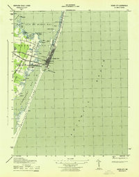
1943 Map of Ocean City
USGS Topo · Published 1943About this map
Ocean City serves as the focal point of this coastal survey, situated on the narrow strip of Fenwick Island between the Atlantic Ocean and the inland bays. This 1943 War Department sheet, compiled by the Corps of Engineers, details the area's vital maritime and transport infrastructure during a critical era of Atlantic defense. The Baltimore and Eastern railroad terminates at the coast, connecting the mainland to the beach via a crossing over Sinepuxent Bay.
Find a feature on this map
43 named features on this map. Tap any name to fly to it.
Don’t see what you’re looking for? This feature index may not catch every label — zoom into the map to look around manually.
Map Details
Editions of this 1943 Ocean City Map
This is the sole edition of this map. No revisions or reprints were ever made.
Other maps of this area

1901 · Green Run
USGS Topo · 1:62,500

1901 · Ocean City
USGS Topo · 1:62,500

1938 · Green Run
USGS Topo · 1:62,500

1942 · Ocean City
USGS Topo · 1:62,500

1942 · Ocean City
USGS Topo · 1:24,000

1942 · Tingles Island
USGS Topo · 1:24,000

1943 · Selbyville
USGS Topo · 1:31,680
1943 · Berlin
USGS Topo · 1:31,680
1943 · Tingles Island
USGS Topo · 1:31,680
1943 · Assawoman Bay
USGS Topo · 1:31,680