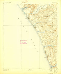
1893 Map of Oceanside
USGS Topo · Published 1897About this map
The San Luis Rey Mission stands as a focal point in the northern hills of this coastal landscape, situated just east of the growing rail hub at Oceanside. Topography by J.B. Lippincott reveals a shoreline defined by series of tidal inlets and lagoons, including Bati Quitos Lagoon and San Elijo Lagoon, which had not yet been significantly altered by modern development. The Southern California Railroad dictates the pattern of settlement, threading south through Carlsbad and Encinitas along the bluffs of the Pacific Ocean.
Find a feature on this map
29 named features on this map. Tap any name to fly to it.
Don’t see what you’re looking for? This feature index may not catch every label — zoom into the map to look around manually.
Map Details
Editions of this 1893 Oceanside Map
2 editions found
Other maps of this area

1893 · Oceanside
USGS Topo · 1:62,500

1893 · Escondido
USGS Topo · 1:62,500

1898 · Oceanside
USGS Topo · 1:62,500

1901 · Escondido
USGS Topo · 1:62,500

1901 · Oceanside
USGS Topo · 1:62,500

1901 · San Luis Rey
USGS Topo · 1:125,000

1902 · Capistrano
USGS Topo · 1:125,000

1903 · La Jolla
USGS Topo · 1:62,500

1904 · Southern California Sheet No. 2
USGS Topo · 1:250,000

1906 · Capistrano
USGS Topo · 1:125,000