
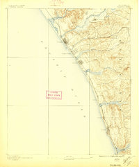
1893 Map of Oceanside
USGS Topo · Published 1893About this map
The San Luis Rey Mission stands as a focal point in this coastal survey, anchoring a landscape where established Spanish-era sites met the rapid arrival of the American railroad. Along the shoreline, early town plats for Oceanside, Carlsbad, and Encinitas are clearly defined, showing the initial street grids that would eventually merge into a continuous coastal corridor. The Southern California Railroad tracks parallel the coast, dictating the placement of settlements like South Oceanside and Lucadia.
Find a feature on this map
28 named features on this map. Tap any name to fly to it.
Don’t see what you’re looking for? This feature index may not catch every label — zoom into the map to look around manually.
Map Details
Editions of this 1893 Oceanside Map
2 editions found
Other maps of this area

1893 · Escondido
USGS Topo · 1:62,500

1898 · Oceanside
USGS Topo · 1:62,500

1901 · Escondido
USGS Topo · 1:62,500

1901 · Oceanside
USGS Topo · 1:62,500

1901 · San Luis Rey
USGS Topo · 1:125,000

1902 · Capistrano
USGS Topo · 1:125,000

1903 · La Jolla
USGS Topo · 1:62,500

1904 · Southern California Sheet No. 2
USGS Topo · 1:250,000

1906 · Capistrano
USGS Topo · 1:125,000

1930 · La Jolla
USGS Topo · 1:62,500