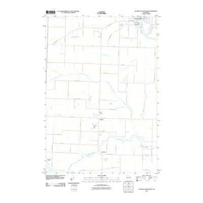
2010 Map of Oconto Falls South
USGS Topo · Published 2010About this map
Oconto Falls occupies the northeast corner of this quadrangle, where the Oconto River is managed by the Lower Oconto Falls 1857c195 Dam. This landscape is defined by the winding courses of the Pensaukee River and its tributary, the North Branch Pensaukee River, which drain the agricultural lowlands and the expansive Morgan Marsh. Small rural communities like Morgan, Sampson, and Krakow are distributed along a grid of county highways and local roads, many of which carry family names like Degantown Rd and Gallas Rd.
Find a feature on this map
50 named features on this map. Tap any name to fly to it.
Don’t see what you’re looking for? This feature index may not catch every label — zoom into the map to look around manually.
Map Details
Editions of this 2010 Oconto Falls South Map
This is the sole edition of this map. No revisions or reprints were ever made.
Other maps of this area

1954 · Green Bay
USGS Topo · 1:62,500

1955 · Seymour
USGS Topo · 1:62,500

1955 · Green Bay
USGS Topo · 1:250,000

1956 · Gillett
USGS Topo · 1:62,500

1956 · Oconto Falls
USGS Topo · 1:62,500

1974 · Abrams
USGS Topo · 1:24,000
1974 · Lena
USGS Topo · 1:24,000
1974 · Oconto Falls North
USGS Topo · 1:24,000
1974 · Gillett
USGS Topo · 1:24,000

1974 · Zachow
USGS Topo · 1:24,000