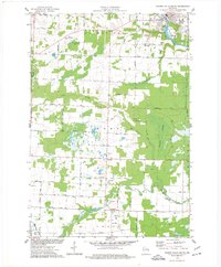
1974 Map of Oconto Falls South
USGS Topo · Published 1977About this map
Oconto River defines the northeastern corner of this Oconto County landscape, flowing past the city of Oconto Falls and the Flats Recreation Area. The geography transitions from the river's path into the extensive Morgan Marsh, while the Pensaukee River winds through the southern townships of Morgan and Chase. This 1974 survey documents a rural infrastructure deeply tied to family-named roads and agrarian centers, such as Sampson and the area surrounding St Johns Ch. Local education and community nodes are preserved through the locations of the Degantown Sch and Fairview Sch, along with the Volk Cem near the northern boundary. The presence of numerous Gravel Pits and Sandpits scattered across the township suggests the active role of local glacial deposits in the regional economy during the mid-1970s.
Find a feature on this map
35 named features on this map. Tap any name to fly to it.
Don’t see what you’re looking for? This feature index may not catch every label — zoom into the map to look around manually.
Map Details
Editions of this 1974 Oconto Falls South Map
This is the sole edition of this map. No revisions or reprints were ever made.
Other maps of this area

1954 · Green Bay
USGS Topo · 1:62,500

1955 · Seymour
USGS Topo · 1:62,500

1955 · Green Bay
USGS Topo · 1:250,000

1956 · Gillett
USGS Topo · 1:62,500

1956 · Oconto Falls
USGS Topo · 1:62,500

1974 · Abrams
USGS Topo · 1:24,000
1974 · Lena
USGS Topo · 1:24,000
1974 · Oconto Falls North
USGS Topo · 1:24,000
1974 · Gillett
USGS Topo · 1:24,000

1974 · Zachow
USGS Topo · 1:24,000