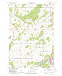
1974 Map of Oconto West
USGS Topo · Published 1977About this map
The Oconto River and Little River converge near the eastern edge of this mid-1970s landscape, framing the city of Oconto during a period of transition. The city is detailed with a grid of streets including Main St and Bridge St, while the surrounding countryside is defined by an extensive network of family and descriptive named roads like La Follette Road, Hogsback Rd, and Military Road. This area shows a blend of public history and industry, notably preserved at Copper Culture State Park and active at the numerous Gravel Pits scattered across the township.
Find a feature on this map
54 named features on this map. Tap any name to fly to it.
Don’t see what you’re looking for? This feature index may not catch every label — zoom into the map to look around manually.
Map Details
Editions of this 1974 Oconto West Map
This is the sole edition of this map. No revisions or reprints were ever made.
Other maps of this area

1939 · Porterfield
USGS Topo · 1:48,000

1941 · Coleman
USGS Topo · 1:48,000

1942 · Coleman
USGS Topo · 1:48,000

1942 · Porterfield
USGS Topo · 1:48,000

1950 · Coleman
USGS Topo · 1:48,000

1954 · Iron Mountain
USGS Topo · 1:250,000

1954 · Escanaba
USGS Topo · 1:250,000

1954 · Manitowoc
USGS Topo · 1:250,000

1955 · Green Bay
USGS Topo · 1:250,000

1956 · Oconto
USGS Topo · 1:62,500