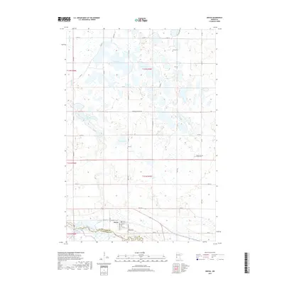
2019 Map of Odessa
USGS Topo · Published 2019About this map
The settlement of Odessa sits along the northern banks of the Minnesota River, serving as a focal point for this section of Big Stone County. The landscape is defined by the glacial depressional wetlands and prairies typical of western Minnesota, with numerous named bodies of water such as Otrey Lake, Larson Lake, and Long Tom Lake scattered across the township. For those tracing local heritage, several denominational burial grounds are documented, including the Odessa Trinity Lutheran Cem and Odessa Immanuel Lutheran Cem. The drainage patterns are clearly visible through the meandering course of Stony Run as it makes its way toward the larger river valley. Infrastructure in the area consists primarily of a rectilinear grid of county roads and local routes like Co Hwy 10 and Co Hwy 21, which navigate the many sloughs and basins that characterize this prairie pothole region.
Find a feature on this map
31 named features on this map. Tap any name to fly to it.
Don’t see what you’re looking for? This feature index may not catch every label — zoom into the map to look around manually.
Map Details
Editions of this 2019 Odessa Map
This is the sole edition of this map. No revisions or reprints were ever made.
Other maps of this area
1953 · Ortonville
USGS Topo · 1:62,500
1953 · Bellingham
USGS Topo · 1:62,500
1953 · Milbank
USGS Topo · 1:250,000
1958 · Milbank
USGS Topo · 1:250,000
1958 · Correll
USGS Topo · 1:24,000
1968 · Artichoke Lake NW
USGS Topo · 1:24,000
1968 · Artichoke Lake
USGS Topo · 1:24,000
1971 · Dismal Swamp
USGS Topo · 1:24,000
1971 · Odessa
USGS Topo · 1:24,000
1971 · Bellingham
USGS Topo · 1:24,000