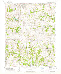
1963 Map of Odessa South
USGS Topo · Published 1964About this map
Odessa serves as the primary hub of this 1963 survey, situated along the Gulf Mobile and Ohio railroad. This region of West Central Missouri is characterized by the branching drainage of the North Fork Blackwater River and South Davis Creek, creating a landscape defined by sharp elevation shifts between upland townships and river valleys. The map documents long-standing rural community centers such as Woods Chapel and several outlying religious sites including Mt Tabor Ch and McKendree Ch. Cultural and civic organization is reflected in the early townships of Sni A Bar, Washington, and Columbus. Genealogists will find particular value in the survey's precise positioning of the Odessa Cem, while the county line between Lafayette and Johnson Counties provides a clear boundary for regional historical research.
Find a feature on this map
17 named features on this map. Tap any name to fly to it.
Don’t see what you’re looking for? This feature index may not catch every label — zoom into the map to look around manually.
Map Details
Editions of this 1963 Odessa South Map
This is the sole edition of this map. No revisions or reprints were ever made.
Other maps of this area

1885 · Warrensburg
USGS Topo · 1:125,000

1887 · Harrisonville
USGS Topo · 1:125,000

1887 · Warrensburg
USGS Topo · 1:125,000

1889 · Lexington
USGS Topo · 1:125,000

1892 · Harrisonville
USGS Topo · 1:125,000

1894 · Harrisonville
USGS Topo · 1:125,000

1894 · Independence
USGS Topo · 1:125,000

1894 · Warrensburg
USGS Topo · 1:125,000

1947 · Jefferson City
USGS Topo · 1:250,000

1947 · Lawrence
USGS Topo · 1:250,000