1981 Map of Oelwein SE
USGS Topo · Published 1982About this map
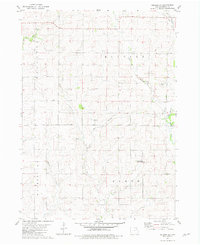
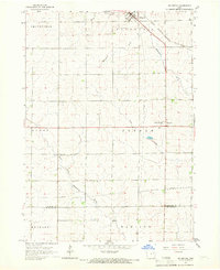
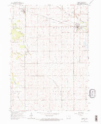
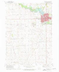
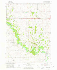
The agricultural landscape of northern Buchanan County is defined by its intricate drainage patterns, where the headwaters of several prominent creeks begin their southward journey. This early 1980s survey illustrates a region dominated by the intersection of four townships—Hazleton, Buffalo, Washington, and Byron—where small family-named landmarks like Spangler Cem and the settlement of Fenner persist amid the section lines. The drainage systems of the East Branch Otter Creek and both the East and West branches of Buffalo Creek create a rolling topography that breaks the geometric regularity of the farmland. Conservation efforts are anchored by the Van Laningham County Wildlife Area in the southeast, providing a rare pocket of uncultivated terrain. Smaller tributaries such as Harter Cr and Malone Creek further detail the rural hydrology of this Iowa prairie-forest transition zone.
Find a feature on this map
15 named features on this map. Tap any name to fly to it.
Don’t see what you’re looking for? This feature index may not catch every label — zoom into the map to look around manually.
Map Details
Editions of this 1981 Oelwein SE Map
This is the sole edition of this map. No revisions or reprints were ever made.
Other maps of this area

1901 · Oelwein
USGS Topo · 1:125,000

1903 · Winthrop
USGS Topo · 1:125,000

1959 · Dubuque
USGS Topo · 1:250,000

1961 · Dubuque
USGS Topo · 1:250,000

1962 · Dubuque
USGS Topo · 1:250,000
1965 · Arlington
USGS Topo · 1:24,000
1965 · Lamont
USGS Topo · 1:24,000
1973 · Independence
USGS Topo · 1:24,000
1973 · Quasqueton
USGS Topo · 1:24,000
1973 · Winthrop
USGS Topo · 1:24,000