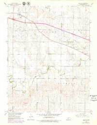
1961 Map of Ogallah
USGS Topo · Published 1979About this map
Ogallah Oil Field defines much of the northern landscape on this Kansas High Plains survey, where petroleum extraction sits alongside a deeply established agricultural and rail network. The Union Pacific railroad cuts diagonally across the northern townships, serving the small community of Ogallah and the siding at Riga. While the landscape appears open, it is punctuated by local centers of civic life such as Emanuel Ch and the Round Mound Sch near the prominent topographic feature of Round Mound. Drainage patterns follow Big Creek and Spring Creek, which wind through the township boundaries of Ogallah and Glencoe. This 1979 revision updates the mid-century topography with 1978 aerial data, capturing the continued operation of numerous oil wells and gravel pits within the prairie terrain.
Find a feature on this map
20 named features on this map. Tap any name to fly to it.
Don’t see what you’re looking for? This feature index may not catch every label — zoom into the map to look around manually.
Map Details
Editions of this 1961 Ogallah Map
2 editions found
Other maps of this area

1893 · Ellis
USGS Topo · 1:125,000

1893 · Hill
USGS Topo · 1:125,000

1955 · Great Bend
USGS Topo · 1:250,000

1955 · Beloit
USGS Topo · 1:250,000

1957 · Great Bend
USGS Topo · 1:250,000

1958 · Great Bend
USGS Topo · 1:250,000

1959 · Beloit
USGS Topo · 1:250,000
1960 · Trego Center NE
USGS Topo · 1:24,000
1961 · Ogallah
USGS Topo · 1:24,000
1961 · Ellis
USGS Topo · 1:24,000