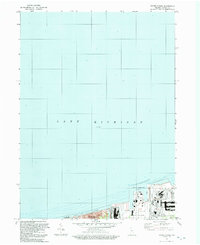
1991 Map of Ogden Dunes
USGS Topo · Published 1992About this map
Lake Michigan dominates the northern expanse of this 1991 survey, which captures the industrial and natural juxtaposition of the Indiana coastline. The landscape is defined by the protected sands of the Indiana Dunes National Lakeshore and the West Beach Recreational Area, which neighbor the heavy infrastructure of the Burns International Harbor. This era represents a period of significant maritime activity at the Port of Indiana, shown alongside the residential development of Ogden Dunes and the growing city of Portage. The map provides a precise record of the shoreline and corporate boundaries between Westchester and Burns Harbor, illustrating how the region's shipping economy and environmental conservation efforts occupied the same stretch of dunes and deep water late in the twentieth century.
Find a feature on this map
14 named features on this map. Tap any name to fly to it.
Don’t see what you’re looking for? This feature index may not catch every label — zoom into the map to look around manually.
Map Details
Editions of this 1991 Ogden Dunes Map
This is the sole edition of this map. No revisions or reprints were ever made.
Other maps of this area

1900 · Toleston
USGS Topo · 1:62,500

1934 · Porter
USGS Topo · 1:48,000

1940 · Porter
USGS Topo · 1:62,500

1953 · Gary
USGS Topo · 1:24,000

1953 · Garyton
USGS Topo · 1:24,000

1953 · Ogden Dunes
USGS Topo · 1:24,000

1953 · Chesterton
USGS Topo · 1:24,000

1953 · Dune Acres
USGS Topo · 1:24,000

1953 · Chicago
USGS Topo · 1:250,000

1957 · Chicago
USGS Topo · 1:250,000