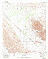
1963 Map of Ogilby
USGS Topo · Published 1970About this map
The Cargo Muchacho Mts dominate this Colorado Desert landscape, a region defined by early twentieth-century mining and modern irrigation engineering. Extensive mining activity is documented through numerous named shafts and sites including the Golden Cross Mine, American Girl Mine, and the Padre Madre Mine, centered around the Hedges (Site) and its associated Hedges Cem. These industrial operations are situated northeast of Ogilby, a key stop along the Southern Pacific railroad line which cuts diagonally across the Pilot Knob Mesa.
Find a feature on this map
37 named features on this map. Tap any name to fly to it.
Don’t see what you’re looking for? This feature index may not catch every label — zoom into the map to look around manually.
Map Details
Editions of this 1963 Ogilby Map
2 editions found
Other maps of this area

1903 · Yuma
USGS Topo · 1:125,000

1905 · Yuma
USGS Topo · 1:125,000

1907 · Holtville
USGS Topo · 1:125,000

1940 · Yuma
USGS Topo · 1:62,500

1942 · El Centro
USGS Topo · 1:250,000

1942 · Yuma
USGS Topo · 1:250,000

1942 · Blythe
USGS Topo · 1:250,000

1945 · Picacho Peak
USGS Topo · 1:62,500

1945 · Picacho
USGS Topo · 1:62,500

1945 · Yuma
USGS Topo · 1:62,500