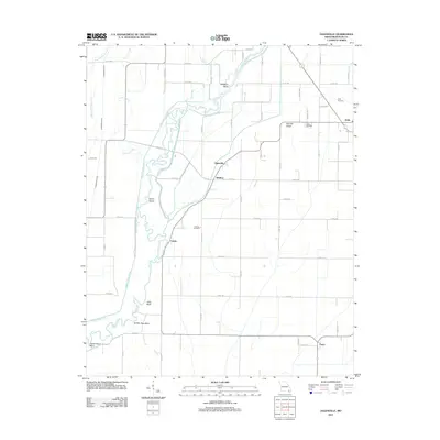
2011 Map of Oglesville
USGS Topo · Published 2011About this map
Black River meanders through the lowlands of Butler County, Missouri, creating a complex network of sharp turns and sloughs such as Devils Elbow and Shotgun Bend. The landscape is defined by the tension between these natural waterways and an extensive drainage system designed to manage the bottomlands, including the Black River Ditch and Ackerman Ditch. This intersection of geography is particularly evident near Melville Ridge, where slightly higher ground provided space for early settlements and burials.
Find a feature on this map
39 named features on this map. Tap any name to fly to it.
Don’t see what you’re looking for? This feature index may not catch every label — zoom into the map to look around manually.
Map Details
Editions of this 2011 Oglesville Map
This is the sole edition of this map. No revisions or reprints were ever made.
Other maps of this area

1935 · Rector
USGS Topo · 1:62,500

1935 · Harviell
USGS Topo · 1:62,500

1940 · Valley Ridge
USGS Topo · 1:62,500

1940 · Piggott
USGS Topo · 1:62,500

1956 · Valley Ridge
USGS Topo · 1:62,500

1956 · Piggott
USGS Topo · 1:62,500

1957 · Poplar Bluff
USGS Topo · 1:250,000

1958 · Rector
USGS Topo · 1:62,500

1959 · Poplar Bluff
USGS Topo · 1:250,000
1960 · Rector
USGS Topo · 1:62,500