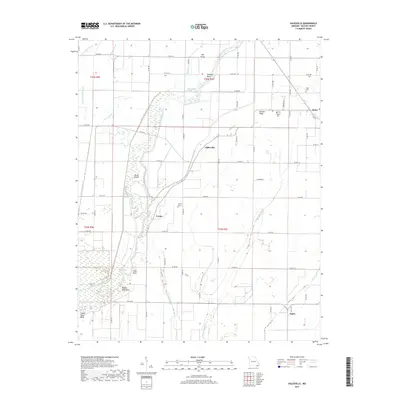
2017 Map of Oglesville
USGS Topo · Published 2017About this map
Black River meanders through this portion of Butler County, shaping a landscape defined by an intricate network of waterways and drainage ditches. The 2017 survey documents the low-lying terrain of the Missouri Bootheel, where the river's path is marked by distinctive features like Shotgun Bend and Big Elm Eddy. The area's agricultural character is evident in the extensive system of man-made channels, including Black River Ditch, Cache River Ditch, and Swan Pond Ditch, which manage the water levels across the plains surrounding Melville Ridge. Small settlements and historic rural centers such as Qulin, Oglesville, Carola, and Fagus serve as anchors for the local community. Genealogists will find several resting places documented, including Kelly Cem, Qulin Cem, and Carola Cem. The map also highlights natural landmarks such as Big Island and the elevation of Gillis Bluff, providing a comprehensive view of the region's topography.
Find a feature on this map
74 named features on this map. Tap any name to fly to it.
Don’t see what you’re looking for? This feature index may not catch every label — zoom into the map to look around manually.
Map Details
Editions of this 2017 Oglesville Map
This is the sole edition of this map. No revisions or reprints were ever made.
Other maps of this area

1935 · Rector
USGS Topo · 1:62,500

1935 · Harviell
USGS Topo · 1:62,500

1940 · Valley Ridge
USGS Topo · 1:62,500

1940 · Piggott
USGS Topo · 1:62,500

1956 · Valley Ridge
USGS Topo · 1:62,500

1956 · Piggott
USGS Topo · 1:62,500

1957 · Poplar Bluff
USGS Topo · 1:250,000

1958 · Rector
USGS Topo · 1:62,500

1959 · Poplar Bluff
USGS Topo · 1:250,000
1960 · Rector
USGS Topo · 1:62,500