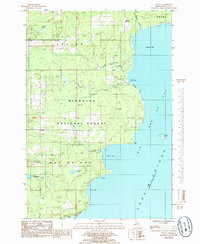
1985 Map of Ogontz
USGS Topo · Published 1985About this map
Big Bay De Noc dominates this mid-1980s coastal survey of Michigan’s Upper Peninsula, revealing a landscape defined by the expansive Hiawatha National Forest and the winding course of the Ogontz River. The settlement of Ogontz sits near the northern shoreline, where the river meets Ogontz Bay. This environment is characterized by its numerous water bodies, including Little Lake Sixteen, Boufford Lake, and Indian Town Lake, which reflect the region's complex glacial geography. Local industry and land use are visible through the noted Limestone Quarry and Gravel Pit, providing a glimpse into the natural resource extraction that supported the area's development. Small coastal features like St Vital Pt Point and the nearby St Vital Island mark the transition into the open waters of Lake Michigan, while the Ogontz Bay Public Access indicates the recreational value of this shoreline.
Find a feature on this map
26 named features on this map. Tap any name to fly to it.
Don’t see what you’re looking for? This feature index may not catch every label — zoom into the map to look around manually.
Map Details
Editions of this 1985 Ogontz Map
This is the sole edition of this map. No revisions or reprints were ever made.
Other maps of this area

1932 · Rapid River NE
USGS Topo · 1:31,680

1932 · Burnt Bluff NW
USGS Topo · 1:31,680

1932 · Garden NW and SW
USGS Topo · 1:31,680

1932 · Rapid River NW
USGS Topo · 1:31,680

1932 · Rapid River SE
USGS Topo · 1:31,680

1932 · Rapid River SW
USGS Topo · 1:31,680

1954 · Escanaba
USGS Topo · 1:250,000

1957 · Escanaba
USGS Topo · 1:250,000

1958 · Escanaba
USGS Topo · 1:250,000

1958 · Garden
USGS Topo · 1:62,500