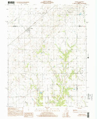
1998 Map of Ohlman
USGS Topo · Published 2002About this map
Ohlman stands at the intersection of a sprawling rural grid in central Illinois, serving as a primary settlement node during this 1998 survey. The landscape is defined by its agricultural layout and the intricate drainage of the Sangamon River and Pana Creek, which carve through the townships of Rosamond and Audubon. Genealogists will find particular value in the documentation of the Rosamond Grove Cem, Ohlman Cem, and Shiloh Ch, which anchor the local community history. The map also marks the significance of the Third Principal Meridian, a critical surveying line that governs the land divisions across several counties. Further south, the small settlement of Bailey and the headwaters of Ramsey Creek illustrate the transition into more deeply dissected terrain, where steel and wooden pole transmission lines cross the open fields.
Find a feature on this map
25 named features on this map. Tap any name to fly to it.
Don’t see what you’re looking for? This feature index may not catch every label — zoom into the map to look around manually.
Map Details
Editions of this 1998 Ohlman Map
This is the sole edition of this map. No revisions or reprints were ever made.
Other maps of this area

1944 · Ramsey
USGS Topo · 1:62,500

1946 · Ramsey
USGS Topo · 1:62,500

1946 · Nokomis
USGS Topo · 1:62,500

1947 · Pana
USGS Topo · 1:62,500

1947 · Hillsboro
USGS Topo · 1:62,500

1949 · Hillsboro
USGS Topo · 1:62,500

1949 · Nokomis
USGS Topo · 1:62,500

1949 · Pana
USGS Topo · 1:62,500

1958 · Decatur
USGS Topo · 1:250,000

1961 · Decatur
USGS Topo · 1:250,000