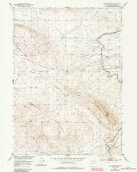
1951 Map of Oil Mountain
USGS Topo · Published 1985About this map
Oil Mountain anchors this high-desert landscape in Natrona County, where early-century petroleum development and water engineering define the terrain. The presence of an Artesian Well and numerous oil-related features, including the Iron Creek Oil Field and an Inactive Oil Well, illustrates the region's industrial footprint during the post-war era. Water management is central to the area's utility, visible through the Casper Canal, Johnson Ditch, and Johnson Reservoir, which divert flow through the arid basins surrounding Poison Spider Creek. The map also captures the path of the Oregon Trail Road as it follows historical migration corridors through the central Wyoming hills. This intersection of historic trail routes and modern resource extraction provides a clear look at how human activity adapted to the harsh geography between Meadow Creek and Clevidence Draw.
Find a feature on this map
19 named features on this map. Tap any name to fly to it.
Don’t see what you’re looking for? This feature index may not catch every label — zoom into the map to look around manually.
Map Details
Editions of this 1951 Oil Mountain Map
3 editions found
Other maps of this area

1950 · Emigrant Gap
USGS Topo · 1:24,000

1950 · Emigrant Gap NE
USGS Topo · 1:24,000

1951 · Oil Mountain
USGS Topo · 1:24,000

1951 · Clarkson Hill
USGS Topo · 1:24,000

1951 · Emigrant Gap NW
USGS Topo · 1:24,000

1951 · Poison Spider
USGS Topo · 1:24,000

1951 · Bessemer Mountain
USGS Topo · 1:24,000

1951 · Benton Basin NE
USGS Topo · 1:24,000

1951 · Reid Canyon
USGS Topo · 1:24,000

1955 · Casper
USGS Topo · 1:250,000