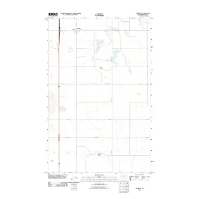
2011 Map of Oilmont
USGS Topo · Published 2011About this map
Oilmont stands as a focal point in this portion of Toole County, characterized by a transition from industrial energy extraction to wide-open ranching land. The northern section of the map is dominated by the Kevin-Sunburst Oil Fld, a significant landmark of Montana's petroleum history, centered near the Oilmont Post Office. To the south, the landscape shifts toward agricultural and ranching operations, marked by the Morton Ranch and a network of section-line roads like Gus Blaze Rd and Sauby Rd. Water management is evident through local infrastructure including the Flesch Number 2 Dam and Kelleher Dam. The terrain is punctuated by physical features such as Raglan Butte, which overlooks the grid of rural routes that define this prairie landscape.
Find a feature on this map
17 named features on this map. Tap any name to fly to it.
Don’t see what you’re looking for? This feature index may not catch every label — zoom into the map to look around manually.
Map Details
Editions of this 2011 Oilmont Map
This is the sole edition of this map. No revisions or reprints were ever made.
Other maps of this area

1939 · Sunburst
USGS Topo · 1:62,500

1943 · Antelope Coulee
USGS Topo · 1:62,500

1943 · Shelby
USGS Topo · 1:62,500

1945 · West Butte
USGS Topo · 1:62,500

1954 · Shelby
USGS Topo · 1:250,000

1958 · Shelby
USGS Topo · 1:250,000

1984 · Sweet Grass Hills
USGS Topo · 1:100,000
1986 · Virden
USGS Topo · 1:24,000
1986 · Antelope Coulee SW
USGS Topo · 1:24,000
1986 · Shelby
USGS Topo · 1:24,000