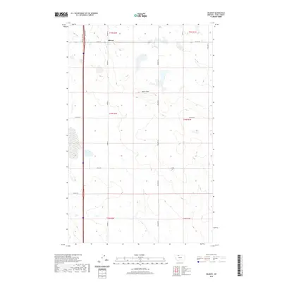
2020 Map of Oilmont
USGS Topo · Published 2020About this map
Oilmont anchors the northern portion of this Toole County landscape, where the high plains of Montana are defined by a grid of local roads and the prominent rise of Raglan Butte. The map details the transition between section lines and the natural topography of the region, showing a network of named routes like Oilmont N and Oilmont S that connect the small settlement to the surrounding ranching and oil-producing territory. To the west, the infrastructure of the interstate corridor is visible through N Frontage Rd and Westside Frontage, which parallel the major thoroughfare. For researchers, the map provides precise locations for family-named thoroughfares including Gus Blaze Rd, Benjamin Rd, and Rogers Rd, illustrating how the land has been partitioned and accessed into the twenty-first century.
Find a feature on this map
20 named features on this map. Tap any name to fly to it.
Don’t see what you’re looking for? This feature index may not catch every label — zoom into the map to look around manually.
Map Details
Editions of this 2020 Oilmont Map
This is the sole edition of this map. No revisions or reprints were ever made.
Other maps of this area

1939 · Sunburst
USGS Topo · 1:62,500

1943 · Antelope Coulee
USGS Topo · 1:62,500

1943 · Shelby
USGS Topo · 1:62,500

1945 · West Butte
USGS Topo · 1:62,500

1954 · Shelby
USGS Topo · 1:250,000

1958 · Shelby
USGS Topo · 1:250,000

1984 · Sweet Grass Hills
USGS Topo · 1:100,000
1986 · Virden
USGS Topo · 1:24,000
1986 · Antelope Coulee SW
USGS Topo · 1:24,000
1986 · Shelby
USGS Topo · 1:24,000