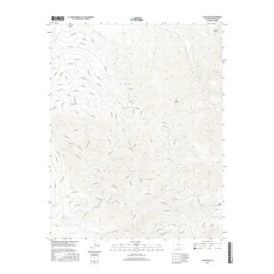
2016 Map of Ojito Peak
USGS Topo · Published 2016About this map
Ojito Peak towers over this pocket of Costilla County, anchored by a dense network of private mountain roads that trace the complex topography of the Sangre de Cristo foothills. Named routes like Montezuma Rd, San Miguel Rd, and Hotchkiss Rd weave through various gulches and canyons, suggesting a landscape segmented by modern rural development or large estate holdings. The hydrology is defined by the headwaters of Ojito Cr and Trinchera Cr, which drain the higher elevations towards the southwest. Along the southern edge of the survey, the Willow Cr Reservoir and the drainage of Rito Seco provide essential water infrastructure in an otherwise arid and elevated terrain. Notable landmarks such as Big Meadow and Squirrel Canyon break the steep contour lines, offering clear reference points for those studying the local geography.
Find a feature on this map
86 named features on this map. Tap any name to fly to it.
Don’t see what you’re looking for? This feature index may not catch every label — zoom into the map to look around manually.
Map Details
Editions of this 2016 Ojito Peak Map
This is the sole edition of this map. No revisions or reprints were ever made.
Other maps of this area

1954 · Trinidad
USGS Topo · 1:250,000

1955 · Trinidad
USGS Topo · 1:250,000

1958 · Trinidad
USGS Topo · 1:250,000
1959 · Trinidad
USGS Topo · 1:250,000
1963 · Mc Carty Park
USGS Topo · 1:24,000
1967 · San Luis
USGS Topo · 1:24,000
1967 · Fort Garland SW
USGS Topo · 1:24,000
1967 · Ojito Peak
USGS Topo · 1:24,000
1967 · Trinchera Ranch
USGS Topo · 1:24,000
1967 · Fort Garland
USGS Topo · 1:24,000