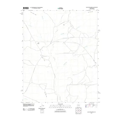
2010 Map of Ojo Encino Mesa
USGS Topo · Published 2010About this map
Ojo Encino serves as the central hub for this high-desert plateau in the Eastern Navajo Agency, where the landscape is defined by extensive mesas and seasonal watercourses. The local geography is etched by deep drainages like Torreon Wash, Encino Wash, and the winding Penistaja Arroyo, which channel runoff between massive geological formations such as Ojo Encino Mesa and Ceja Pelon Mesa. The intersection of multiple Bureau of Indian Affairs routes, including Indian Service Route 471 and Indian Service Route 472, highlights the importance of the settlement's connectivity within this vast traditional landscape.
Find a feature on this map
24 named features on this map. Tap any name to fly to it.
Don’t see what you’re looking for? This feature index may not catch every label — zoom into the map to look around manually.
Map Details
Editions of this 2010 Ojo Encino Mesa Map
This is the sole edition of this map. No revisions or reprints were ever made.
Other maps of this area

1883 · Mt. Taylor
USGS Topo · 1:250,000

1886 · Mt. Taylor
USGS Topo · 1:250,000

1889 · Largo
USGS Topo · 1:250,000

1892 · Mt. Taylor
USGS Topo · 1:250,000

1895 · Largo
USGS Topo · 1:250,000

1899 · Mt. Taylor
USGS Topo · 1:250,000

1954 · Aztec
USGS Topo · 1:250,000

1958 · Aztec
USGS Topo · 1:250,000

1958 · Albuquerque
USGS Topo · 1:250,000
1961 · Ojo Encino Mesa
USGS Topo · 1:24,000
Featured Places
- Eastern Navajo Agency, NM
- Ojo Encino, Eastern Navajo Agency
- Sandoval County, NM
- McKinley County, NM
- United States