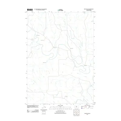
2012 Map of Okaton SW
USGS Topo · Published 2012About this map
White River meanders through the heart of this central South Dakota landscape, defining the topography of the Swift Bear Segment. In the early 21st century, the area remains dominated by wide-ranging livestock operations, with established homesteads such as Peterson Ranch, Graham Ranch, and Blom Ranch anchoring the rural road network. The drainage pattern is particularly intricate here, as numerous tributaries including Cedar Cr, Cottonwood Cr, and Yukmi Cr carve deep draws into the plains before joining the main river channel. This 2012 survey illustrates a classic Great Plains ranching environment, where long-held family holdings like Schwartz Ranch and Sandy Ranch represent the primary human imprint on a land shaped by the forces of the White River's alluvial activity.
Find a feature on this map
12 named features on this map. Tap any name to fly to it.
Don’t see what you’re looking for? This feature index may not catch every label — zoom into the map to look around manually.
Map Details
Editions of this 2012 Okaton SW Map
This is the sole edition of this map. No revisions or reprints were ever made.
Other maps of this area

1951 · Stamford SE
USGS Topo · 1:24,000

1951 · Cedar Butte NE
USGS Topo · 1:24,000

1951 · Okaton SW
USGS Topo · 1:24,000

1951 · Murdo 3 NW
USGS Topo · 1:24,000

1951 · Murdo 3 NE
USGS Topo · 1:24,000

1951 · Okaton SE
USGS Topo · 1:24,000

1955 · Martin
USGS Topo · 1:250,000

1958 · Martin
USGS Topo · 1:250,000

1972 · Okaton
USGS Topo · 1:24,000
1972 · Okaton NE
USGS Topo · 1:24,000