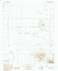
1990 Map of Okie Well
USGS Topo · Published 1990About this map
The Barry M Goldwater Air Force Range dominates this desert landscape along the border of Maricopa and Pima Counties. This 1990 provisional survey documents a transition from the alluvial fans of Childs Valley in the north to the formidable peaks of the Growler Mountains in the south. The rugged elevation culminates at Paisano Peak, while the lowlands are defined by drainage networks like Daniels Arroyo and Tenmile Wash. This map is particularly useful for those tracking the history of range management and conservation, as it shows the overlapping boundaries of the Cabeza Prieta Wilderness and Nat Wildlife Rfg. Evidence of historical water access is sparse, centered on the singular point of Okie Well (Dry) in the eastern flats of Growler Valley.
Find a feature on this map
13 named features on this map. Tap any name to fly to it.
Don’t see what you’re looking for? This feature index may not catch every label — zoom into the map to look around manually.
Map Details
Editions of this 1990 Okie Well Map
This is the sole edition of this map. No revisions or reprints were ever made.
Other maps of this area

1927 · Aguila Mountains
USGS Topo · 1:48,000

1930 · Aguila Mountains
USGS Topo · 1:62,500

1953 · Ajo
USGS Topo · 1:250,000

1957 · Ajo
USGS Topo · 1:250,000

1958 · Ajo
USGS Topo · 1:250,000

1962 · Ajo
USGS Topo · 1:250,000

1963 · Ajo
USGS Topo · 1:250,000

1964 · Growler Peak
USGS Topo · 1:62,500
1965 · Aguila Mountains
USGS Topo · 1:62,500

1965 · Granite Mountains
USGS Topo · 1:62,500