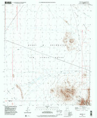
1996 Map of Okie Well
USGS Topo · Published 2000About this map
The Barry M Goldwater Air Force Range dominates this corner of the Sonoran Desert, where military land management overlaps with significant conservation efforts. The landscape is defined by the sharp rise of the Growler Mountains and the arid expanses of Growler Valley and Childs Valley. Resource management is visible through the Cabeza Prieta Nat Wildlife Refuge and the designated Cabeza Prieta Wilderness, protecting a region where water is the primary limiting factor. Evidence of this scarcity is marked at Okie Well (Dry), a site that highlights the difficulty of settlement and cattle ranching in the Maricopa and Pima county borderlands. Drainage patterns such as Tenmile Wash and Daniels Arroyo trace the paths of seasonal runoff across the desert floor, providing the only relief in an otherwise parched environment.
Find a feature on this map
14 named features on this map. Tap any name to fly to it.
Don’t see what you’re looking for? This feature index may not catch every label — zoom into the map to look around manually.
Map Details
Editions of this 1996 Okie Well Map
This is the sole edition of this map. No revisions or reprints were ever made.
Other maps of this area

1927 · Aguila Mountains
USGS Topo · 1:48,000

1930 · Aguila Mountains
USGS Topo · 1:62,500

1953 · Ajo
USGS Topo · 1:250,000

1957 · Ajo
USGS Topo · 1:250,000

1958 · Ajo
USGS Topo · 1:250,000

1962 · Ajo
USGS Topo · 1:250,000

1963 · Ajo
USGS Topo · 1:250,000

1964 · Growler Peak
USGS Topo · 1:62,500
1965 · Aguila Mountains
USGS Topo · 1:62,500

1965 · Granite Mountains
USGS Topo · 1:62,500