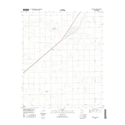
2016 Map of Oklahoma Lane
USGS Topo · Published 2016About this map
Oklahoma Lane and the settlement of Wilsey anchor this high plains landscape in Parmer County. The terrain is defined by the shallow, intermittent paths of Running Water Draw and Progress Draw, which wind through a grid of agricultural section lines and county roads. The map reveals the strictly organized land use of the Texas Panhandle, where transport depends on a network of Farm to Market roads like FM 3333 and FM 2396 alongside traditional ranching routes. Small topographical depressions and cattle tanks dot the sections, illustrating the water management necessary for life and commerce in this semi-arid region during the mid-2010s. For those tracing the evolution of West Texas homesteads, the survey captures the intersection of rural infrastructure and natural drainage patterns that have shaped local settlement for generations.
Find a feature on this map
23 named features on this map. Tap any name to fly to it.
Don’t see what you’re looking for? This feature index may not catch every label — zoom into the map to look around manually.
Map Details
Editions of this 2016 Oklahoma Lane Map
This is the sole edition of this map. No revisions or reprints were ever made.
Other maps of this area

1954 · Clovis
USGS Topo · 1:250,000

1957 · Clovis
USGS Topo · 1:62,500

1957 · Pleasant Hill
USGS Topo · 1:62,500

1958 · Clovis
USGS Topo · 1:250,000

1963 · Lariat
USGS Topo · 1:24,000

1963 · Oklahoma Lane
USGS Topo · 1:24,000

1963 · Lariat NE
USGS Topo · 1:24,000

1963 · Progress
USGS Topo · 1:24,000

1965 · Bovina
USGS Topo · 1:24,000

1965 · Parmerton
USGS Topo · 1:24,000