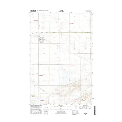
2016 Map of Oklee
USGS Topo · Published 2016About this map
Oklee serves as the primary center of activity in this northern Minnesota landscape, situated at the boundary of Red Lake and Polk counties. The town's grid is clearly defined by streets like Main St, Oak St, and Governor St, reflecting a community organized around its proximity to the Lost River and agricultural infrastructure like Elevator Rd. The surrounding countryside reveals a heavily managed hydrological system, where natural waterways are augmented by a complex network of engineered channels including Judicial Ditch Number Seventyone and County Ditch Number Eightyseven. Local genealogy and history are preserved at the Zion Cem to the north and Saint Francis Xavier Cem to the south. The transition from the flat agricultural plains toward the more varied terrain near the Hill River in the south illustrates the local geography of the Red River Valley's eastern edge.
Find a feature on this map
54 named features on this map. Tap any name to fly to it.
Don’t see what you’re looking for? This feature index may not catch every label — zoom into the map to look around manually.
Map Details
Editions of this 2016 Oklee Map
This is the sole edition of this map. No revisions or reprints were ever made.
Other maps of this area

1919 · Fosston
USGS Topo · 1:62,500

1919 · Grit
USGS Topo · 1:62,500

1919 · Winsor
USGS Topo · 1:62,500

1954 · Bemidji
USGS Topo · 1:250,000

1957 · Bemidji
USGS Topo · 1:250,000

1958 · Bemidji
USGS Topo · 1:250,000

1969 · Olga
USGS Topo · 1:24,000

1969 · Mc Intosh NE
USGS Topo · 1:24,000
1969 · Mc Intosh
USGS Topo · 1:24,000
1971 · Oklee
USGS Topo · 1:24,000