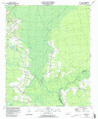
1990 Map of Old Dock
USGS Topo · Published 1991About this map
The Waccamaw River carves a winding path through the heart of this coastal plain landscape, separating the intricate swamp systems of Green Swamp and Boggy Swamp. In the early 1990s, the rural character of southeastern Columbus County is defined by its relationship with water and timber, visible in the extensive network of drainage features like the Mark Pine Canal and White Marsh. Settlement is concentrated along the higher ground bordering these wetlands, particularly at the communities of Old Dock and South Old Dock. These small hamlets and the nearby Riverview serve as local hubs, anchored by institutional landmarks such as the Old Dock Sch and several country churches including Palmyra Ch and Magnolia Ch. The map also captures numerous family-named landmarks and cemeteries like the Formyduval Cem, providing a detailed look at the area's genealogical footprint before modern development expanded.
Find a feature on this map
38 named features on this map. Tap any name to fly to it.
Don’t see what you’re looking for? This feature index may not catch every label — zoom into the map to look around manually.
Map Details
Editions of this 1990 Old Dock Map
This is the sole edition of this map. No revisions or reprints were ever made.
Other maps of this area

1942 · Juniper Creek
USGS Topo · 1:24,000

1943 · Pireway
USGS Topo · 1:31,680

1943 · Nakina
USGS Topo · 1:24,000

1943 · Freeland
USGS Topo · 1:24,000

1943 · Exum
USGS Topo · 1:24,000
1953 · Pireway
USGS Topo · 1:24,000

1953 · Florence
USGS Topo · 1:250,000

1954 · Florence
USGS Topo · 1:250,000

1954 · Bolton
USGS Topo · 1:62,500

1955 · Whiteville
USGS Topo · 1:62,500