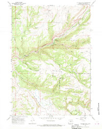
1967 Map of Old Maid Gulch
USGS Topo · Published 1970About this map
Bighorn National Forest landscape in Washakie County is dominated by the dramatic descent of Tensleep Creek through Tensleep Canyon. This 1967 field-checked survey highlights a corridor of mountain recreation and resource management, featuring the Tensleep Fish Hatchery, the Leigh Monument, and several organized sites like Tensleep Campground and Leigh Creek Campground. The map also captures private holdings and seasonal outposts such as the Circle J Ranch and Canyon Lodge, which mark the lower elevations near the canyon mouth.
Find a feature on this map
43 named features on this map. Tap any name to fly to it.
Don’t see what you’re looking for? This feature index may not catch every label — zoom into the map to look around manually.
Map Details
Editions of this 1967 Old Maid Gulch Map
This is the sole edition of this map. No revisions or reprints were ever made.
Other maps of this area

1899 · Cloud peak
USGS Topo · 1:125,000

1901 · Cloud Peak
USGS Topo · 1:125,000

1955 · Sheridan
USGS Topo · 1:250,000

1955 · Arminto
USGS Topo · 1:250,000

1958 · Sheridan
USGS Topo · 1:250,000

1958 · Arminto
USGS Topo · 1:250,000

1962 · Sheridan
USGS Topo · 1:250,000

1962 · Arminto
USGS Topo · 1:250,000

1966 · Monument Hill
USGS Topo · 1:24,000

1966 · Big Trails NE
USGS Topo · 1:24,000